Oahu Flood Crisis 2026: Survival Guide, Evacuation Protocols, and Infrastructure Alerts
Oahu flood update 2026: Wahiawa Dam at record levels, 10,000 evacuated, and major roads closed. Expert survival tips, evacuation routes, and infrastructure status for Hawaii residents.
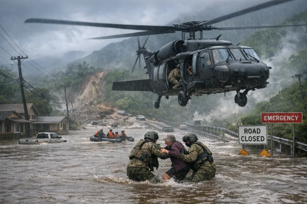
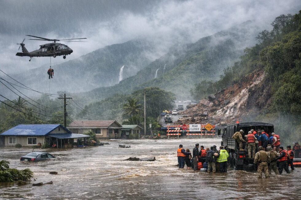
Oahu is currently facing a catastrophic weather event as relentless torrential rains trigger widespread flash flooding, landslides, and life-threatening dam instabilities across the island. The North Shore, particularly the communities of Haleiwa and Waialua, remains the epicenter of the crisis, where over 10,000 residents have been ordered to evacuate as primary transit arteries succumb to mudslides and rising waters. For residents and travelers, understanding the real-time status of the Wahiawa Dam and the failure risks of remaining access roads is no longer just a precaution—it is a mandatory requirement for survival. As of March 21, 2026, the convergence of record-breaking reservoir levels and compromised power grids has created a logistical nightmare for emergency services, making immediate adherence to official directives the only way to mitigate further casualties.
This critical situation is reported by the San Francisco Newsroom via SF Chronicle. According to state officials and the National Weather Service, the island has seen up to 25 centimeters of rain in less than 48 hours, with an additional 10 centimeters forecast within the next day. Governor Josh Green and Honolulu Mayor Rick Blangiardi have mobilized the Hawaii National Guard and the U.S. Army to conduct high-risk aerial extractions, as ground routes to several campgrounds and residential pockets are now completely submerged. The threat is compounded by the “high risk of failure” for the last remaining road out of Waialua, leaving those who refuse to leave at risk of total isolation in a zone where emergency response is increasingly limited to air support.
The Wahiawa Dam Threat: Analyzing Record Water Levels
The Wahiawa Dam remains the most significant structural concern for North Shore safety, as water levels in the reservoir reached an all-time record of 85.3 feet on Friday morning. While levels dipped slightly to 82 feet overnight, the structure is under constant 24-hour surveillance by the U.S. Geological Survey and the Honolulu Department of Emergency Management. A collapse of this dam would release a catastrophic wall of water, directly endangering approximately 5,000 people in the path of the floodgate. Authorities have emphasized that the reservoir typically sits at only 68 feet this time of year, meaning the current volume is nearly 25% above seasonal norms, placing unprecedented hydraulic pressure on the aging infrastructure.
| Metric | Current Status (March 2026) | Historical Average | Risk Threshold |
| Wahiawa Reservoir Level | 82.0 – 85.3 Feet | 68.0 Feet | 90.0 Feet (Spillover/Collapse) |
| Total Rainfall (48h) | 25 – 35 Centimeters | 5.2 Centimeters | N/A |
| Evacuation Count | ~10,000 Residents | N/A | Total Region Population |
| Power Outages | 4,200+ Customers | Minimal | Preventative Shutdowns |
| Rescues Performed | 233+ Individuals | N/A | Emergency Capacity |
| Water Supply Status | Critically Low Pressure | Normal | Broken Main (Ahuimanu) |
| Wastewater Leakage | 30,000+ Gallons | Zero | Environmental Hazard |
Emergency Infrastructure Failures and Power Grid Stability
The integrity of Oahu’s utility services has been severely compromised by the combination of high winds and fast-moving debris, leading to proactive power cuts to protect search and rescue teams. Hawaiian Electric reported that over 6,400 customers lost power at the height of the storm, with over 4,000 still in the dark as of Saturday morning. These outages have created a secondary crisis: the inability to power pumps at critical water wells and reservoirs. The Honolulu Board of Water Supply has issued a mandatory water conservation notice, specifically for the east side of the island where a major water line break in Ahuimanu has drained local storage tanks, leaving households with zero pressure for hygiene or firefighting.
- Conserve Potable Water: Limit usage to drinking and essential cooking only; do not use dishwashers or washing machines.
- Preventative Power Strategy: Charge all backup batteries and satellite communication devices now while intermittent power is available.
- Wastewater Warning: Avoid all contact with streams in Kailua, Ahuimanu, and Waimanalo due to 30,000 gallons of raw sewage overflow.
- Road Safety: Do not attempt to cross moving water; 15 cm of water can stall most cars, and 30 cm can sweep them away.
- Air Travel Logistics: Arrive 90 minutes early for inter-island flights and 3 hours for trans-Pacific flights due to visibility delays.
- Health Watch: Monitor for signs of hypothermia; 10 people have already been hospitalized despite Hawaii’s relatively mild air temperatures.
- Communication: Use text messages instead of voice calls to keep cellular bandwidth open for emergency services.
- Debris Management: Do not touch downed power lines or attempt to clear fallen trees near utility poles.
Survival Protocols for Active Flood Zones and Landslides
In 2026, flood response has evolved to include real-time sensor monitoring, but the physical reality of a landslide remains an unpredictable threat to those in mountainous terrain. Residents in the Sealing and North Shore areas must watch for “warning signs” of shifting earth, such as new cracks in plaster, tilting trees, or a sudden change in water flow in local gullies. If you are in a high-risk zone, the Department of Emergency Management advises moving to the highest floor of your home or an designated shelter immediately. The use of Black Hawk helicopters for camping extractions highlights the reality that once a road fails, you are entirely dependent on federal assets which may be redirected to higher-priority life-saving missions.
Impact on Maui and Lahaina’s Fragile Recovery
The storm system has not spared Maui, where the community of Lahaina—still reeling from the devastating 2023 wildfires—is facing a cruel secondary disaster. The loss of vegetation from the 2023 fires means the soil has zero capacity to absorb the current rainfall, leading to massive runoff and mudslides in areas where 2,200 structures were previously destroyed. Major hospitals on Maui have restricted operations to emergency-only cases as flooding breaches interior facilities. For residents in fire-scarred regions, the risk of “flash mudflows” is significantly higher than in healthy forest areas, requiring a much faster reaction time to evacuation sirens than in previous decades.
Practical Advice: Steps to Take in the Next 12 Hours
If you are currently on Oahu or Maui, your priority is securing your physical safety before the next wave of rain hits Saturday afternoon. Check your “Go-Bag” for essential documents, medications, and at least three days of non-perishable food. If your area is under an evacuation order, do not wait for a knock on the door; local failure of road shoulders can happen in seconds, rendering your vehicle useless. Experts suggest parking vehicles on high ground and facing them toward the exit route to save precious seconds. Additionally, ensure your mobile “Emergency Alerts” are turned on in your phone settings, as this is the primary method for broadcasting dam failure warnings.
- Verify Road Status: Check the HDOT website before moving; do not trust GPS apps which may not reflect recent landslides.
- Sanitize Water: If water pressure returns, boil all water for 3 minutes until the Board of Water Supply clears the “Boil Water Advisory.”
- Document Damage: Take photos of property damage only if it is safe to do so; this will be vital for 2026 insurance claims.
- Stay Informed: Monitor KSSK-FM or other local emergency broadcast stations for Wahiawa Dam updates.
- Check Neighbors: If safe, use a whistle or light signal to check on elderly neighbors who may not have digital access.
- Avoid Streams: The brown-water advisory is in full effect; avoid the ocean and streams to prevent leptospirosis and staph infections.
- Fuel Up: Ensure your vehicle has a full tank of gas; power outages at gas stations will make refueling impossible for days.
- Hospital Access: Avoid going to the ER for non-life-threatening issues; facilities are currently overcapacity with storm victims.
Frequently Asked Questions
Is the Wahiawa Dam expected to fail today?
Engineers are monitoring the 90-foot spillover point. While levels dropped to 82 feet, the dam is still at high risk if the forecasted 10 cm of rain arrives on Saturday.
What should I do if I am trapped by floodwaters?
Move to the highest point of your structure. Do not climb into a closed attic; get onto the roof so rescuers can see you and you are not trapped by rising water.
Are flights out of Daniel K. Inouye International Airport canceled?
Most flights are operating, but expect delays. Check your flight status before leaving for the airport and allow extra travel time for road detours.
Why was the power turned off if my house isn’t flooded?
Hawaiian Electric may de-energize circuits to prevent electrocution risks for first responders wading through water or to prevent fires from downed lines.
When will the water pressure return to Ahuimanu?
Crews are working to repair the broken main, with hopes of restoration by Saturday morning, though this is dependent on weather conditions.
Is it safe to return home once the rain stops?
No. Do not return until authorities declare the area safe. Landslides can occur hours or even days after the rain has stopped due to soil saturation.
San Francisco News keeps the city, the Bay Area and the wider world informed with clear, useful reporting on what matters: How much does it cost to rent an apartment in San Francisco in 2026